The hard lessons of surviving an avalanche in the Tetons
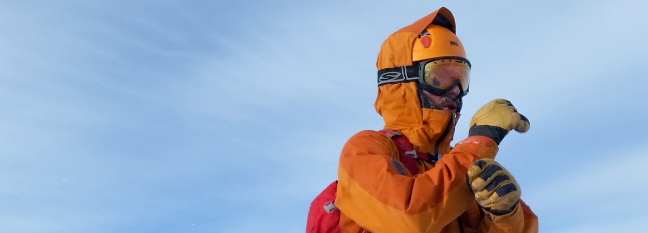
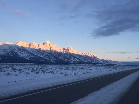
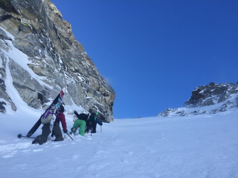
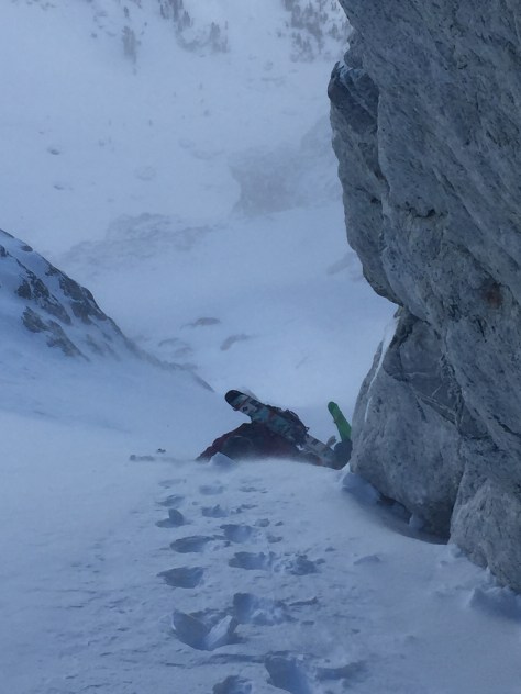
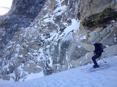
The sky was dark and the air crisp on the morning of February 4 as we skinned toward the Spoon Couloir in Grand Teton National Park. Moving along in meditative unison, my mind began to wander to the events of the past two weeks. A lifelong friend, Darren Johnson, had died in an avalanche while patrolling at the Yellowstone Club on January 19th. This massive loss had ripped a hole in my soul and I was heading into the mountains to repair the damage. I could have never imagined that later in the day I would nearly suffer the same fate as my dear friend……
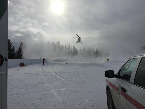
I am writing on the 8 week anniversary of an avalanche in the Spoon Couloir, off Disappointment Peak, that nearly killed me. As many of you know, I was airlifted from Amphitheater Lake by a TCSAR’s helicopter with the expert pilot, Nicole Ludwig at the helm. The Jenny Lake Rangers were incident commanders on the rescue and rangers Case Martin and Jim Martin were the professionals on scene. They performed the extraction from the lake in a matter of minutes and were nothing short of amazing. These two groups are absolutely essential to our community and you should all donate to their causes (TCSAR and Jenny Lake Rangers) to ensure they will act on a moments notice when you are at your most vulnerable point.
After being admitted to St. John’s Medical Center, I had the privilege of having Dr. Heidi Jost as the surgeon who repaired my broken leg. As it turned out, my tibia was broken into 22 pieces and she did an exceptional job putting everything in place and giving me the opportunity for a full recovery. I spent a total of four nights in the hospital, including Super Bowl Sunday, where I “hosted” one of the more expensive four person “party’s” ever.
I have been on the mend since, but it is a slow process. I am suffering from significant PTSD, but making progress moving-albeit at a snails pace. I recently was able to get into a pool and practice putting weight on my leg. Since I have been on crutches and non-weight bearing for the past two months, it was a very strange sensation. Despite the pain, the slight movement was exhilarating. For someone who craves physical activity, the stillness of this recovery has been a huge challenge. Simply being able to move under my own power brought a rare smile to my face.
Powder.com is going to be posting the full account of my experience here on Tuesday April 5th. I will also have an extended version of the article on OutdoorBeta with additional photos. It will share many lessons learned and give everyone an insight into the experience of nearly perishing in an avalanche. Those of us fortunate to live in mountain towns have all heard of people losing their lives in avalanches-doing what they love, but we never think it can happen to us. I can say for certain that I have never heard a story like the one I am going to tell. I hope you all take a moment to read the article, share it with all your friends and let it sink fully into your soul. I was once someone who thought this could never happen to me, but here I am, alive and able to tell my story.
Most importantly, I want to thank my loving girlfriend Zelie Dunn-Morrison and my friends and family for coming to my aid during this trying time in my life. One might think that surviving a near-death experience would be the hardest part of the process, but the emotional impact has been eye-opening. The struggle, anguish and frustration an event like this has on your soul and those around you has been hard to comprehend. Without all of you: Dane Etter-Garrette, Beau Etter-Garrette, Maureen Garrette, Diane Johnson, Brian Close, Mike Bessette, Tyler MacPhie, Tristan Droppert, Danny Filice, Ben and Kate Shanks, Lexie Hunsaker, Brian Donner, Brian Collins, Chase Sandbloom, Paco, Casey and Tom Kalishman, Bill and Lannie Hoglund, Victor Morrison and Patty Dunn, Braden Masselink and many others, I would not be here today moving forward to live another day. I love and thank you all from the bottom of my heart.
~Rene
Location: GTNP, Mount Moran, Jackson Lake, Skillet Glacier
Elevation: 10,780′, 5,094′ gain/loss
Distance: 24 miles RT
Difficulty: 5 stars
Time: 12-16 hours
Trip Report:
Date: 1/16/2016
Snow Conditions: Powder, consolidated powder, faceted powder, crust 20″ under new snow
Skiing the Skillet back in May of 2012 was one of my first major ski descents in the Tetons. I can still remember the feeling I had entering the runout under moonlight, looking upwards 6000′ to the summit of Moran. It took us a long time, but we made it to the top of the Skillet and enjoyed the views from the summit of Moran. We skied the whole “couloir” down to Jackson Lake without issue, despite my alpine boots and lack of skins. Ever since than, I have looked up at Mount Moran and wondered what a 6000′ ski down the Skillet would be like in winter conditions. You certainly couldn’t paddle a canoe to Bearpaw Bay, or bring a 12 pack for the afterparty-but the advantages would be the potential powder. The Skillet lies in one of the more remote places in GTNP, requiring a 7miles (one way) skin from Colter Bay and a 6000′ climb to the summit of Moran. This type of day requires a level of fitness and snow conditions that don’t happen often. With that said: Dane, Brian Close and I decided to give it a try on Saturday with the weather conditions calling for snow after 11am….
With all this in mind, we left Jackson at 5:15am and were moving from Colter Bay at 6:25am. It was dark, but I used my Suunto Traverse to make the way in the direction of the northern edge of the Skillet Couloir. We continued on for about an hour in the dark until the sun stared to shine through and at that point, we realized we were on target-heading right for the Skillet!
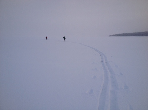
Around this time we crossed our first of three major areas of “slush pockets”. These occur when, “the ice cracks and water can rush up through the crack on top of the ice but under the insulating snow, and form slush pockets. These slush pockets can become very broad, sometimes covering entire lakes under the snow, and they are a hazard to travelers.” (Wintertrekking.com)
These points on a skin are a little scary, considering we had yet to hear of anyone crossing Jackson Lake and it was very early in the morning. Regardless-we gingerly continued on and hoped for the best. We had been making great time for the first half of the lake (about 3.5mph), but the last half was SLOW and we hit land at 9:25am, 3hrs after beginning.
After cleaning off our skis (the slush freezes quickly) we ate some food and got our gear ready for the climb up the Skillet. It was around this time I realized that the handle of my Black Diamond pole was hanging on by a thread. I touched it and it fell off my pole….
After some wonderful “Gorilla Tape” construction by Dane, my pole was functional, but not ideal-considering it was missing the handle. It was only 120cm long, not the 145cm I usually skin with, but we had to move on. We worked our way up and to the left through willows and tight pines, until we were finally in the runout of the Skillet. Here we took a look at the time and saw that we needed to move fast. It had begun to snow lightly over the past hour and we were still around 5000′ from the summit. We continued up, stopping only once to drink water-very aware of the time we had to make up.
The snow was exceptionally deep and we were not able to make good time. We worked our way into the gut of the couloir, finding more consolidated snow in avy paths on the lower portions of the run. We continuously were looking around and taking check of the snow conditions. We didn’t see any “major” concerns, despite the fact it was snowing on a huge line in a remote area-so we continued up. At around 9000′, the sun crept out of the clouds and we were greeted with limited visibility. The couloir appeared to have flushed at some point in the past few days and the wind was blowing from the northwest….with this new information, we continued on and into the belly of the Skillet.
At about 10,000′ the run mellows out into a 20 degree zone with massive cliffs on either side. Here, there clouds rolled in and the snow picked up. We moved up for a while, but eventually the sound of snow flushing off the upper reaches of the mountain became too much to ignore. We stopped at 10,780′ on a raised portion of the belly to discuss going further. We could see the last cliff band in the couloir that we had to overcome before the “handle” of the Skillet. We had a quick chat about what to do next, but there wasn’t much of a discussion to have. Everything would have had to happen in our favor for this to be a success and with the visibility near zero, we only had once choice….ski down to the lake. While we were disappointed, the snow was DEEP and we had a blast ripping our way down to the lake.
We tried for something most wouldn’t even consider and failed. While it was a tough pill to swallow, I am confident to be back at the Skillet in the near future to accomplish the rare feat. We made it back across the lake and to Colter Bay just before sunset, 11hrs after starting. We were tired, thirsty and cold-but at least we tried.
Location: GTNP, Prospectors Mountain, Open Canyon
Elevation: 11,180′, 4,894′ gain/loss
Distance: 14 miles RT
Difficulty: 3+ stars
Time: 6-9 hours
Trip Report:
Date: 1/13/2016
Snow Conditions: Powder, consolidated powder between 10,000′ and 8,000′, wind crust up high-first 400′, sun affected snow down low
Tuesday night, while tuning some skis at Teton Village Sports–Tristan and I discussed what we should ski the following morning. There was a chance of some weather blowing in, so we immediately ruled out a few objectives we had been eyeing in the high alpine and decided on skiing something that I was able to accomplish last year. The Banana Couloir is not quite a couloir, but rather a large gully that runs from the northeastern shoulder of Prospectors Mountain into Open Canyon. It is fairly steep towards the top, but mellows out near the bottom. It is a big avalanche path and does have a cliff/waterfall at its precipice, so it is not a run to be taken lightly.
Good view of the entire Banana
The main difficulty with the run is the route finding. When we skied it last year, we went north on Moose-Wilson Rd, then cut left at a point and broke trail into Open Canyon. This worked, but I thought that going towards Olive Oil on the normal skin track, then continuing on into the canyon would be a little faster. I also wanted to test out my navigation capabilities on my new Suunto Traverse. I mapped out the route to the base of the Banana the night before and was hopeful that it would work.
Tristan, Stu and I left the Granite Canyon Trailhead at 7:25am as another group was getting ready a few cars away. As we passed them, we asked what they were planning on skiing-already pretty sure it was the Banana because of the ice axes. They confirmed our suspicions, but we were going to have a head start and felt comfortable sharing the line if we had to.
We cruised out on Moose-Wilson Rd., cutting left into the woods about a half-mile from the trailhead. We followed the track all the way to the northeast ridge of Olive Oil, then continued right (North) into Open Canyon. We were following an old skin track, but my Suunto said we were on target-so we continued on. Eventually, we made our way into the canyon and a clearing. We knew we were a little ways down canyon from the end of the couloir, but decided to take the faded skin track in front of us up for a bit, then cut left and make our way into the Banana.
View of the top of the line from the field.GPS. You can see that our uptrack was a bit right of the Banana to start.
We worked our way up on the track, eventually breaking trail left at 8,600′. We knew that the “V-Couloir Gully” was pretty nasty and wanted to be below that. It worked out perfectly and we made our way across that gully and then into the east ridge of the Banana.
Looking down the “V-Couloir Gully”
We cruised up the ridge, slipping at times on a sun crust/faceted snow, but making good time. Towards the top, we bootpacked a steep section-then continued skinning to the upper bowl. At the bowl, we bootpacked up-eventually reaching a spot near the top, but not actually on the summit (It is part of the Winter Wildlife Closure in the Mt. Hunt area). We topped out at 5hrs, which was almost 2hrs faster than the last time I skied this line.
After quickly gearing up, we decided on a plan of attack for the upper portion of the run and gave it a go. The top 400′ was wind affected and a bit grabby. It was a little slow going, but still fun snow. Once off the upper bowl, the snow became consolidated and very fun. Some people call it “cream cheese snow” and whatever your name is for it, the snow was fun! We skied down in a few pushes, not wanting to waste the big open run with numerous stops. The snow near the bottom was a little isothermal in spots, but it was still fun and we made it down to the canyon floor in no time.
After making it down to the bottom, we worked our way down canyon until we caught the track back to Olive Oil. It was a very easy out and we were soon skating back to the truck on Moose-Wilson Rd. We made it to the trailhead in 6hrs 30min, pleased with the day and conditions. Once again–another fun day in GTNP schussing around.
A day after heading up Garnett Canyon to ski The Nugget, I once again was skinning up the canyon for a schuss. Dane, Zelie, Lexie and I had decided to take a look at West Hourglass off Nez Perce. I have skied it a couple times, but was hopeful that the conditions would be better than past skis. It seems to get a lot of wind based on its location in Garnett and is typically wind scoured, but based on the day before, I thought we had a shot for couloir powder.
We left Bradley/Taggart at 8:30am and within no time we were in the Meadows where we came upon a group of two skiing down towards us. They stopped and chatted for a second, saying they bailed on the West Hourglass because of 6″ windslabs and a crust on the lower apron of the run. We took what they said with a grain of salt and decided to have a look for ourselves. They beauty of Garnett is that there is always another line you can ski if you decide to bail on your first objective.
As we worked our way up to the apron of the Hourglasses, we didn’t see the slabs they were talking about, but did notice a pretty solid wind crust. We decided to continue up and assess the situation as we progressed. Here, the skinning wasn’t too bad besides a few buff spots and we were at the base of the Hourglasses fairly quickly.
East Hourglass looking skiable!
At the base of the West Hourglass, we took our skins off and stashed them near a rock. When doing this, I lost control of Dane’s rolled skins and they went careening down the apron and out of sight-Oops! We later found them, but it was a reminder that you never can be too careful with your gear in the mountains. With that behind us, we started up the initial first pitch. I would guess it reaches 45 degrees and has a fairly large rollover at the top. We knew this would be the most dangerous part of the climb and stayed close to each other near the lookers left wall.
On the up at the first pitch of the couloir
About 100′ from the top of the pitch, Dane tapped out below a safe spot and I continued on solo over the rollover. It was hard going, but I made it up and over into a safe zone. The others continued up to me as the wind began to howl, moving snow down the couloir and into the void.
After the group reached my spot, we all took a look up the couloir and saw it was not in great shape. There was numerous wind ripples in the snow and what appeared to be bulletproof snow throughout much of the middle section. Regardless, we continued on to the top. The going was fairly easy, with only the upper section holding deepish snow.
Nearing the top
We stopped about 200′ from the true top of the couloir, because it looked to be unskiable at this point in the year. We took our time getting ready, snapping a few pictures and eventually were ready for some old fashioned survival skiing!
Having a look at the Grand
Zelie, with the top 200′ looking rough
The skiing down wasn’t as bad as I had thought. In spots is was a little unpredictable, but the wind ripples were soft and the firm snow wasn’t awful. We made our way down to rollover with anticipation of powder turns and velvet snow…
Lexie navigating the upper/middle section
Looking down the middle portion to the rollover
We gathered at the rollover and decided I’d ski it halfway down and then the rest of the group take it down to the gear stash. While we were not too concerned about the snow moving, this would have been the spot to go if it decided to. It was very stable and pretty deep on the skiers right side of the pitch-which more than made up for the rest of the lines subpar snow.
Jumping into the rollover
Slash…
We gathered our gear and made our way down the apron, making a pit stop to grab Dane’s skins which had stopped about 500′ down the slope. The skiing here was at times great and others terrifying. The wind crust was inconsistent and very grabby in places. We all made it down safe, but there were a few dicy turns that kept us on edge.
After regrouping in the Meadows, we cruised out of the canyon and made our way back to Bradley Lake. The snow was decent on the last pitch above the lake, but still a little thin and slightly grabby. We cruised across the lake and eventually to the truck in 7hrs. While the snow wasn’t the best, it was still great to get into the park on a double date–who needs dinner and a movie!? Keep on Adventuring.